Current model runs are showing the potential for winter weather precipitation in the northwestern areas of our region as we move into tomorrow morning between 3am and Noon. Currently the transportation impacts are impacted to be minimal, however it does not take much for overpasses and bridges in our area to become hazardous. Monitor evening forecasts tonight as they should provide more accurate information on how far south the freezing precipitation line may move.
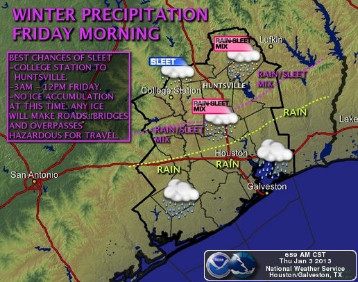
An upper level disturbance is expected to move into Southeast Texas Friday morning with plenty of mid and upper level moisture. Low level moisture and temperature profiles in the atmosphere become favorable for rain and sleet or just sleet north of a Brenham to Livingston line including areas from College Ctation to Huntsville. Sleet and rain mix will be possible from about 3 am to 12 pm Friday for these areas. So far only a few hundredths of an Inch to a tenth of an inch of rain is expected but no ice accumulations are expected at this time. It would not take much Sleet accumulation to make roads…overpasses and bridges slick and hazardous for travel. Please monitor forecasts today and tonight for the possibility of a winter weather advisory should Ice accumulations become possible.