The National Weather Service has issued a Hard Freeze Watch effective Tuesday eventing through Wednesday morning. The Watch is expected to be upgraded to a Warning sometime tomorrow.
Severe Weather and Freeze
A strong arctic front is moving toward the region and is bringing a risk of severe weather Tuesday as it moves though our region followed by high freeze risk as it passes. The front has the potential to bring us the coldest weather of the 2011 season thus far. As the front moves through Tuesday, our main risk for severe weather is between 5am – 11am, and possibly earlier for the regions to the northwest. Sustained winds of 30 mph with gusts near Tropical Storm Force (45mph) from about late morning through the evening hours can be expected. Temperatures will fall into the 30s and 40s by late Tuesday afternoon followed by a Hard Freeze Tuesday night for the majority of the region except for near the immediate coast. Wind chills will be from approximately 5-20 degrees.
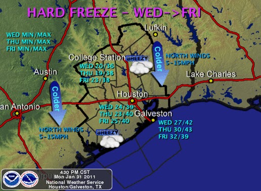
The air mass is expected to remain in place Wednesday through Friday bringing a hard freeze to the region during the nighttime hours. Daytime temperatures may not make it above the 30s in may parts of the area and the windchill will remain in the single digits and teens.
Winter Precipitation Potential
Moisture will then be brought back into the region by an upper level disturbance sometime between Thursday night and Friday morning bringing the potential for mixed frozen precipitation and/or snow. The amounts will be dependent largely on when the disturbance hits our area.
Remember to take care of your Pets, Plants, Pipes, Sprinkler Systems, and Family Members.