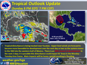
There is currently a tropical disturbance off the coast of the Yucatan that has an 80% chance of development over the next few days. Current model guidance suggests it will make landfall in the central to northern Texas Coast sometime Monday-Wednesday.
Currently the conditions in the Gulf of Mexico are favorable for intensification. Due to already saturated ground, the rainfall amounts of 5-10 inches with up to 15 inches isolated accompanying the landfall of this tropical disturbance could lead to a dangerous flood threat in the region.
Please stay tuned to WxWarn and local news outlets for updates.
 |
| Source: National Weather Service Houston/Galveston |
 |
| Tropical Disturbance Model Guidance Source: WeatherUnderground |
 |
| Quantitative Precipitation Forecast (next 72 hrs) Source: NOAA Weather Prediction Center |


