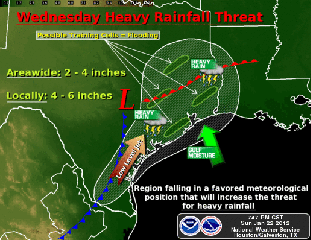
Tuesday night and Wednesday will most likely bring us the strongest system as abundant moisture and favorable upper level winds are predicted . Rainfall amounts in the region are predicted to average 1-3 inches with a potential of 4-6 inches likely in localized areas if storm cell training occurs. Some cells may become severe with a potential threat of isolated tornados.
Following this rain event, we still have a 20% chance of rain on Thursday following this event as the system progresses. However this could change as we are still a few days out.
The highs throughout the week are predicted to stay in the mid 60s to low 70s while lows should stay in the mid 40s to mid 50s.
Don’t forget the rain gear and take care on the roads!


