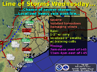
As we mentioned earlier in the week, a wet Tuesday night and Wednesday is still expected. A strong upper level storm system will move slowly through over the next 24-36 hours. The National Weather Service reports scattered thunderstorms will develop overnight and become more numerous toward morning. Some storms could be severe with the potential to generate damaging winds and isolated tornados. Rainfall accumulations throughout the region are still expected to be around 1-2 inches with localized rainfall amounts of up to 5 inches if storm cell training occurs.
Thursday morning still has a 20% chance of precipitation, however the chance diminishes into the afternoon as the system moves further east.
Stay dry and stay safe!


