A very intense winter storm system has started to impact parts of Texas beginning yesterday and is expected to last for several days.
Currently…
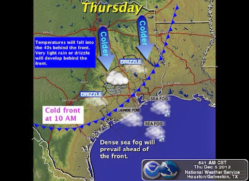
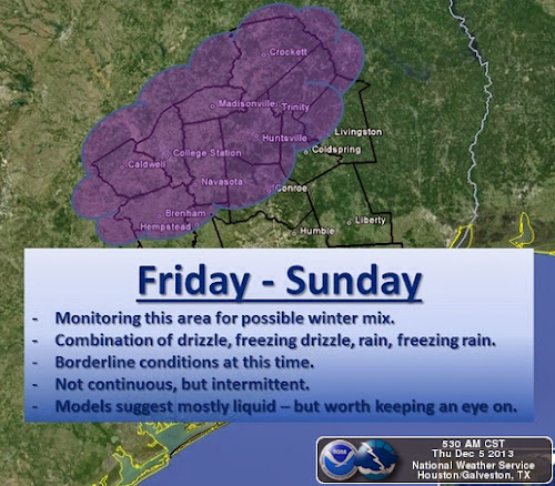
The front continues to make good southward progress and will be through the Houston Metro area before noon and offshore by mid afternoon. Temperatures will fall 20-25 degrees with the frontal passage and continue to cool quickly into the 40’s by afternoon with temps possibly in the upper 30’s in the norther and northwestern areas of our region. Significant rainfall is not expected with the front, but chances for rain will increase overnight into Friday. There is a significant threat of freezing drizzle/rain Friday through Sunday based on the current models, especially for the northern areas of Southeast Texas.
Accumulations of ice from Friday evening – Sunday morning of .01 to .05 of an inch will be possible north of a line from Brenham to Conroe to Livingston.
Please note that areas just north of our region all the way up to north Texas are expected to experience hazardous winter weather conditions for the next few days. The State of Texas Division of Emergency Management (TDEM) reports the following:
“Multiple rounds of precipitation can be expected with snow and sleet impacting the Texas Panhandle and Northwest Texas and freezing rain and sleet impacting North, Northeast and Central Texas. Power outages are likely in these areas due to ice accumulation on power lines and due to falling tree limbs. Travel on roadways will be very hazardous as ice and snow accumulate and stick to roads, bridges and overpasses.”
The following sources provide good sources of information for the upcoming events in North Texas and should be shared with people in that area to allow them to prepare accordingly.
TDEM Winter Weather Brief 1000 CST 12/5/2013
TDEM Potential Winter Weather SITREP-1 12/4/13
Following the passage of this front, a secondary arctic surge will arrive into our region Monday. Bringing a hard freeze risk to areas north of I-10 by Tuesday morning. Be prepared to protect your pet, pipes, and plants.


