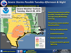
A strong slow-moving storm system will impact the Southeast Texas region on Tuesday and Wednesday bring a Flash Flood and isolated Severe Weather threat.
Timing
Rain chances slowly pick-up starting early Tuesday morning. Current models indicate the heavier rain is expected to start Tuesday from Noon-4pm CST, with high potential for severe weather starting in the late afternoon Tuesday and continuing though Wednesday.
Rainfall Threat
Widespread amounts totaling 4-6 inches are possible across the region. Isolated amounts of 8-10 inches are possible. The current rainfall intensity models of this system have been increasing in throughout the day today. If this continues, potential isolated rates could climb higher. Hourly rainfall rates of 2-3 inches per hour can be expected. With this rainfall potential, there is a high risk of flash flooding. The heaviest rainfall is expected to the east of the region (approximately East of the Hwy 290 and I-45 South line)
 |
| NOAA WPC – Quantitative Precipitation Forecast 72hr |
Severe Weather Threat
The primary hazards are:
- Strong Damaging Winds
- Isolated Tornadoes
- Frequent Lighting
The Storm Prediction Center reports the West side of the region has the greatest risk of severe weather although isolated events could be seen anywhere across SE Texas. With high levels of sheer and deep layer wind fields, there is the potential for super cell development along with severe winds and hail.
 |
| NOAA NWS HGX Graphicast |
Stay tuned to your local media thought the day Tuesday and Wednesday. Play close attention to weather conditions during your commutes. Stay indoors during severe weather and do not enter roadways that are underwater. Turn Around, Don’t Drown.


